


浙江舟山市普陀区
∨


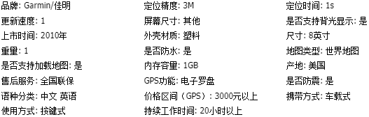

高分辨率的8.4寸SVGA彩色液晶显示屏
坚固耐用,防水IPX7级,水下1米30分钟不进水
内置高感高精度GPS接收芯片,定位精度高达3~5米
简单、直观的智能操作界面,操作更简单
内置不同于其它传统地图的世界范围的底图和详细中国沿海海图;可选配世界范围内其他区域的详细海图
可选配GSD21/GSD22测深模块或数字测深探头,增加渔探/测深功能;搭配多种探头,最大测深可达1500米
标准NMEA0183输入输出,支持RS-232C和RS-422格式
可存储5000个航点,每个航点可编辑名称、图标、符号、注释等
可存储50条航线可自动记录35000个航迹点,最多可存储30条航迹
选购件:
海外海图使用,另购海图卡,一张2600元,需要联系客服.
测深鱼探模块:RMB:3500 壁挂式探头RMB:1200


| 工作电压 | 10~36V |
| 工作温度 | -15℃~+55℃ |
| 尺寸:长x宽x深(毫米) | 284.4*176.9*106 |
| 重量 | 1.3公斤 |
| 防水级别 | IPX7 |
| 耗电 | 最大7.5W(12V供电) |
| NMEA输入/输出 | NMEA0183 |
| 自动调整亮度 | 无 |
| 屏幕类型 | SVGA彩色液晶 |
| 屏幕大小 | 6.9“x5.2 |
| 屏幕分辨率 | 800*600 |
| 天线类型 | 外置(标配) |
| 内置海图 | 详细中国沿海海图 |
| 可选配海图 | 是 |
| 航点 | 5000 |
| 航线 | 50 |
| 航迹记录 | 35000个航迹点/30条航迹 |
| 兼容GARMIN雷达 | 否 |
| 兼容GARMIN声纳 | GSD21/22 |
| 兼容GARMIN网络 | 否 |
| 支持AIS船舶显示 | 是 |
| 支持DSC船舶显示 | 是 |
| 潮汐表 | 是(需配G2卡) |
| 日月信息 | 是 |
| 立体海图 | 否 |
| 无线遥控 | 无 |
| 无线鼠标 | 无 |
| 视频输入/输出 | 无 |
| 标准数据接口 | 2组NMEA0183输入,2组NMEA0183输出 |
- GPMAP2008主机
- GPS天线
- 电源线/NMEA0183数据线
- 保护面盖
- 嵌入式安装配件
- U形安装支架和旋钮
- 使
- GPSMAP 2008 chartplotter has sunlight readable and high resolution quality on an 8” SVGA
- (800 x 600 pixels) display, easy to flush-mounts or bail-mounts in your boat. Features designed
- specifically for professional fishermen at more affordable cost to larger display chartplotters. The
- 2008 also sports a built-in, worldwide basemap and simple, straightforward buttons and menus.
- You can add the optional BlueChart® g2 SD card for more enhanced map features. Except with
- English user interface (UI), the 2008 is the first Garmin chartplotter equipped with Asian language
- pack, including Traditional Chinese, Simplified Chinese, Indonesian Bahasa, Thai, and Myanmar.
-
Navigate with Ease
With just a few buttons and a simple, intuitive interface, the GPSMAP 2008 makes navigating virtually
Add Sonar
Where applicable, the GPSMAP 2008 can connect with a powerful sounder (GSD21) and dual frequency
-
transducer that clearly paints depth contours, fish targets and structure whether you’re fishing in freshwater
-
or off the coast. Capable of connecting to Garmin NMEA 0183 Intelliducer for various depth fathoming sensors.
-
The GPSMAP 2008 is also CANet™ compatible, so you can share sounder data with another chartplotter on
-
your boat.用手册和安装手册简介
-
effortless. The GPSMAP 2008 has an SD™ card slot so you can add additional detailed maps worldwide
-
without connecting to a computer.

商品评价
0%好评
共有0人参与评分